Research Article | | Peer-Reviewed

Rainfall Variability and Prolonged Drying of the Menarandra Riverbed (2000–2017) in the District of Bekily (Southern Madagascar)

Received: 4 January 2026     Accepted: 15 January 2026     Published: 2 February 2026
Views:       Downloads:
Abstract

The Menarandra River, located in the Androy region of southern Madagascar, flows through a semi-arid environment characterized by severe water stress, a long dry season lasting seven to nine months, and a short, highly variable rainy season concentrated between December and March. Rainfall records from the Bekily meteorological station over 2000–2017 highlight pronounced interannual variability, with alternating wet years (e.g., 2001, 2005, 2011, annual totals >1,000 mm) and deficit years with totals below 700 mm (e.g., 2002, 2004, 2016, 2017). To better link raw rainfall data to effective rainfall in terms of hydrological response, the analysis incorporates the Turc formula, widely used in water balance studies to estimate potential evapotranspiration and effective rainfall. This approach allows a more precise characterization of hydrological conditions associated with rainfall variability and their potential role in riverbed drying. Rainfall analysis is complemented by qualitative interpretation of Google Earth satellite images processed in QGIS, together with field observations. Comparison of images from December 2014 and October 2018 reveals marked reduction and fragmentation of water-covered areas, indicating increasing spatial discontinuity of surface flow. While the temporal correspondence between rainfall variability and riverbed drying suggests a strong association, river intermittency likely reflects the combined influence of seasonal and interannual rainfall patterns and local hydrological controls. Overall, results indicate a progressive shift of the Menarandra toward a more intermittent flow regime, improving understanding of river drying dynamics in semi-arid southern Madagascar and informing sustainable water resource management under increasing drought conditions.

Published in Earth Sciences (Volume 15, Issue 1)
DOI 10.11648/j.earth.20261501.13
Page(s) 30-43
Creative Commons

This is an Open Access article, distributed under the terms of the Creative Commons Attribution 4.0 International License (http://creativecommons.org/licenses/by/4.0/), which permits unrestricted use, distribution and reproduction in any medium or format, provided the original work is properly cited.

Copyright

Copyright © The Author(s), 2026. Published by Science Publishing Group

Keywords

Menarandra River, Rainfall Variability, Prolonged Drying, Minor and Middle Riverbed, Hydrological Regime, Southern Madagascar

1. Introduction
Southern Madagascar is characterized by a semi-arid climate with low and irregular rainfall, mainly concentrated during a short rainy season, and long dry periods that can last from seven to nine months . This climatic variability strongly influences the hydrological regimes of the region's intermittent rivers, where flows are fragmented and the Menarandra Riverbed is subject to recurrent drying . In the Androy region, the Menarandra River can remain dry for nearly five months each year, and its numerous tributaries only flow during the rainy season, reflecting a strongly intermittent regime . The Menarandra River, which crosses the Bekily district, rarely reaches its mouth , characterizing it as a river with an intermittent fluvial regime.
Previous studies have mainly focused on the variability of river regimes and the influence of the semi-arid climate on regional hydrology . However, few studies have systematically assessed the impact of interannual rainfall variability on prolonged drying of the Menarandra Riverbed, representing a significant gap in understanding local hydrological dynamics and planning sustainable water resource management in semi-arid areas.
In this study, the period analyzed covers 2000–2017. The link between interannual rainfall variability and drying of the Menarandra Riverbed is explored by combining rainfall data analysis, the application of the Turc formula to estimate effective rainfall and evapotranspiration, and the interpretation of satellite imagery and field observations.
Therefore, the objective of this study is to assess the risk of prolonged drying of the Menarandra Riverbed, focusing on the effects of rainfall variability, in order to provide scientific evidence for integrated and sustainable management of river systems.
This study was conducted in the district of Bekily, in three fokontany: Anivorano (Ankaranobo-North commune), the town center of Bekily, and Fangola (Ambahita commune). Geographically, Bekily is located approximately 200 km from the regional capital of Androy. With an area of 5,575 km², the district comprised, in 2021, 19 communes and 228 fokontany . Its total population was estimated at 7,454 inhabitants . Economic activities in the region are mainly agro-pastoral. The majority of the population practices rainfed agriculture, cultivating staple crops including rice, maize, sweet potato, cassava, and legumes (beans, peanuts, etc.). Livestock farming also constitutes an important part of local livelihoods. This strong dependence on rainfed agriculture makes the population particularly vulnerable to interannual rainfall variability and prolonged drought periods, which directly influence water availability and food security.
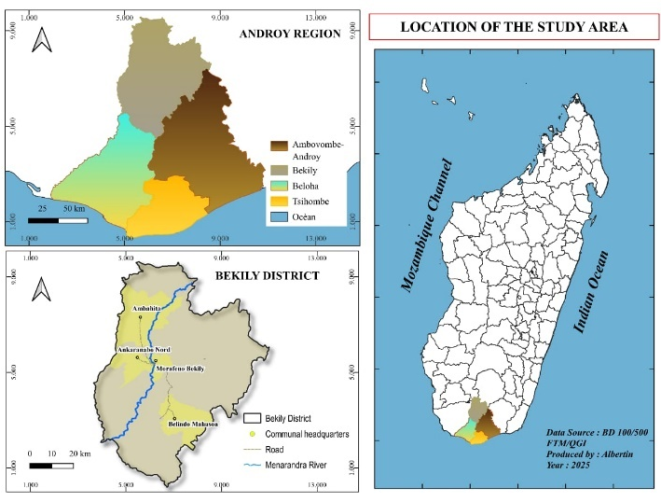
Figure 1. Location of the study area: Bekily district.
2. Methodology
The methodological approach adopted combines three main components: documentary research, field investigations, and satellite image analysis, complemented by a quantitative analysis of rainfall using the Turc formula to estimate effective rainfall.
2.1. Documentary Research
The study began with a documentation phase carried out in several university libraries and documentation centers in Madagascar. At the University of Toliara, research was conducted at the Tsiebo Calvin Library, the CEDRAToM Library (Center for Documentation and Research on Spatial Planning and the Environment), the GPCEHP Doctoral School Library, as well as the Alliance Française Library. This phase continued in Ambovombe-Androy, at the library of the University Center of the Androy Region, providing access to works specific to the Androy region and the extreme south of Madagascar. In parallel, we analyzed reports from international organizations operating in the district, such as ADRA, Action Against Hunger (ACF), Action Inter-cooperation of Madagascar, the World Food Programme (WFP), and UNICEF, particularly in the context of combating food insecurity and improving living conditions. Finally, this stage was completed through consultation with the Anti-Locust Service (VALALA) in Bekily, which provided local rainfall data covering the period 2000–2017.
2.2. Fieldwork
The second phase consisted of field surveys conducted in the district of Bekily in October 2025 and December 2025, along villages bordering the Menarandra River, notably Anivorano (Anivorano commune), the town center of Bekily, and Fangola (Ambahita commune). During this mission, semi-structured interviews were carried out with different categories of key informants, including 03 fokontany heads, 03 community leaders, 10 women, and 09 men who are local leaders. These participants took part in the 02 focus groups conducted. The interviews made it possible to collect their perceptions regarding the drying periods of the Menarandra River, the problems encountered locally, and the socio-economic importance of the river. At the same time, direct observations were carried out to assess the presence or absence of water in the minor and middle channels, the depth of flows, and the continuity or fragmentation of the river course. Photographs were also taken to document the condition of the riverbed at the time of the visit.
2.3. Collection of Satellites Images from Google Earth Maxar
The third phase consisted of utilizing satellite images available on Google Earth (Maxar) to analyze the drying of the Menarandra Riverbed along the Bekily section. For each study year (2014 and 2018), we observed the portions of the riverbed still covered by water and those that had dried up. To represent these observations accurately, we used Google Earth’s polygon tracing feature. This feature allows one to “draw” directly on the satellite image the areas where water is present. Once these areas were drawn, they were exported in KML format, a type of computer file containing information about shapes and geographic locations. In other words, the KML file, which stands for Keyhole Markup Language, a markup language for representing geographic information, “records” the traced areas so that they can be used in other mapping software. Next, these KML files were imported into QGIS, a geographic information system (GIS) software, enabling the creation of precise maps. These maps clearly illustrate areas still covered by water, dried zones, and the fragmentation of the riverbed. This method allows for visualizing the spatial evolution of the Menarandra’s drying over several years and provides a better understanding of the river’s dynamics over time.
This method allows visualizing the spatial evolution of Menarandra’s drying over several years and provides a better understanding of the river’s dynamics.
2.4. Rainfall Analysis and Turc Formula
To link interannual rainfall variability to the prolonged drying of the Menarandra Riverbed, we applied the complete Turc formula to estimate effective rainfall (Pe), i.e., the fraction of precipitation actually available to generate runoff:
Pe=P2P+P2+L2
Where:
L=100+25T+0.05T3
Pe = effective rainfall (mm)
P = annual precipitation (mm)
T = mean annual temperature (°C)
L = temperature-related factor representing atmospheric demand.
This approach allows quantifying the rainfall actually available for flow in the Menarandra Riverbed. linking low effective rainfall to prolonged drying periods observed in the field and on satellite images and providing a quantitative basis to interpret the effects of rainfall variability on river intermittency and riverbed fragmentation.
2.5. Study Limitations
This study presents certain methodological limitations related to the available data. First, no continuous discharge series for the Menarandra River are available for the period 2000–2017, creating a temporal mismatch between hydrological observations and rainfall. To address this limitation, the analysis relies on effective rainfall estimated using the Turc formula, complemented by field observations and the interpretation of satellite images, allowing a robust assessment of the riverbed drying despite the absence of direct flow measurements. Moreover, the interannual variability of precipitation will be characterized using statistical indices such as the coefficient of variation of annual totals and standardized anomalies, in order to link rainfall variability to changes in the hydrological regime. Finally, the analysis of satellite images presents uncertainties related to image resolution and the qualitative nature of interpretation;
3. Results and Discussion
In this section, the analyses focus on rainfall variability, its effects on the drying of the Menarandra Riverbed, as well as the impacts on riverbed morphology and the local socio-economic domain.
3.1. Rainfall Variability Between 2000 and 2017
The analysis of rainfall variability in Bekily is based on data collected from the local weather station, provided by the Bekily Anti-Locust Service (VALALA).
Table 1. Rainfall in Bekily between 2000 and 2005 (mm).

Year

2000

2001

2002

2003

2004

2005

J

305,5

234,6

123,6

174,7

116,3

330,7

F

29,7

177,7

303,8

111,7

115,7

161,6

M

05

212,7

34,2

36,6

57,1

38,2

A

78,3

15,4

08

33,3

06

01,8

M

14,5

0,6

0

2,3

2,2

36,4

J

0

0

0

2,199

0

3,3

J

12,2

0

13,2

0

15,5

0

A

05,3

01,3

0

52,5

12,5

0

S

00,3

0

23,2

95,4

9,4

20,5

O

01

18,8

0

95,4

88,9

89,3

N

169

101,2

12,3

205,6

16,2

97,099

D

180,3

439,8

68,2

146,6

195,6

325,79

Total

801,1

1202,1

586,5

956,299

635,4

1104,689

Source: Bekily Anti-Locust Service, 2025
The examination of monthly rainfall totals in Bekily shows a clear concentration of rain during the short wet season, between December and March, while most of the other months record very low values, often below 20 mm. Specifically, during the wet season (December to March), rainfall is relatively high but variable. For example, in January, significant totals are observed in 2000 (305.5 mm), 2001 (234.6 mm), and 2005 (330.7 mm), while other years such as 2002 and 2004 remain low (123.6 mm and 116.3 mm). February 2002 and 2004 show 303.8 mm and 115.7 mm, respectively, highlighting marked year-to-year variations. In contrast, rainfall drops drastically after March, during the so-called intermediate season (April to June), with very low monthly totals, often below 10 mm (e.g., April 2002: 8 mm; May 2004: 2.2 mm; June 2000 and 2002: 0 mm). These months correspond to the prolonged dry period, accentuating the hydrological vulnerability of the river. During the dry season (July to November), almost all months are characterized by negligible rainfall, often close to zero (July 2001, August 2002: 0 mm), with only occasional sporadic rains. November 2003 (205.6 mm) represents a notable exception, likely linked to isolated meteorological events. This seasonal pattern is consistent with observations , which note that southern Madagascar is characterized by a short and highly irregular rainy season and a long dry season that can exceed seven months. Similarly, Battistini indicates that the high interannual variability of rainfall in southernmost Madagascar is a major factor in the hydrological instability of rivers . In Bekily, the duration of the dry months is long, often extending from May to November, with a particularly critical period from June to September when rainfall is almost nil. This monthly pattern confirms the semi-arid nature of the region.
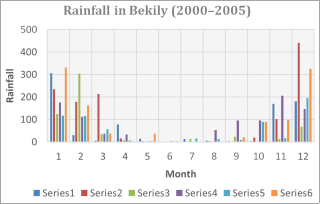
Figure 2. Interannual rainfall in Bekily between 2000 and 2005.
Sometimes, cyclonic events strongly influence annual rainfall and can cause short-term precipitation peaks in the region. In 2004, the passage of Cyclone Elite (February 2004) produced 115.7 mm of rainfall, and Cyclone Gafilo (March 2004) produced 57.1 mm of rainfall. These values show that cyclones generated a significant but short-term water input. Despite this, rainfall remained low for the rest of the year (April: 6 mm; May: 2.2 mm; June: 0 mm; July: 15.5 mm), confirming that the prolonged dry season dominates the hydrological regime of the Menarandra River.
Standard deviation calculation
σ=1ni=1n(xi-x̅)2
where
1) xi = i-th value (value (Annual total rainfall)
2) x̅ = mean of the values
3) n = number of values
σ=16i=16(xi-881,02)2
σ227,4 mm
Annual rainfall in Bekily between 2000 and 2005 varies on average by ±227 mm from the mean of 881 mm, confirming a high interannual variability.
Table 2. Rainfall in Bekily between 2011 and 2017 (mm).

Year

2011

2012

2013

2014

2015

2016

2017

J

407

174,6

126

358,4

51,5

24,5

318,9

F

232,2

77,4

351,9

114,2

292,6

194,8

0

M

39,2

75,4

0

12,7

46,5

112,6

116,4

A

102,4

114,6

13,7

29,1

37

0

0

M

36,2

114,6

18,8

21,2

12,3

0

0

J

01,7

0

0

0,3

0

8,3

0

J

20,7

0

0

2,5

0

5,9

0

A

32,1

0

0

0

11,3

0

0

S

0

0

10

0

15

0

0

O

16

34,3

217,1

53,8

53,2

27,2

0

N

0,01

76,6

44,7

10,6

25

30,9

71,6

D

137,9

214,6

37,5

60,6

143,5

160,1

182,2

Total

1025,41

882,1

819,7

663,4

687,9

564,3

689,1

Source: Bekily Anti-Locust Service, 2025
The examination of monthly rainfall totals in Bekily shows that the wet season is mainly concentrated between December and March, while the rest of the year is dominated by dry conditions. January and February are the wettest months but exhibit high interannual variability. In January, high totals were recorded in 2011 (407 mm), 2014 (358.4 mm), and 2017 (318.9 mm), contrasting with very low values observed in 2015 (51.5 mm) and 2016 (24.5 mm). This intra-seasonal irregularity is characteristic of semi-arid climates subject to strong variability.
February can occasionally show exceptional rainfall peaks, such as in 2013 (351.9 mm), directly linked to the passage of Cyclone Haruna (22–23 February 2013). Conversely, years such as 2012 (77.4 mm) and 2017 (0 mm) illustrate the extreme variability of rainfall inputs. Cyclonic events in southern Madagascar generate intense but brief rainfall, whose hydrological impact remains limited in time in the absence of regular precipitation .
In March, rainfall is generally low or absent, except in 2016 (112.6 mm) and 2017 (116.4 mm). The period from April to June marks the transition to a prolonged dry season, with almost no rain in 2016 and 2017 (0 mm). The months from July to September are almost consistently dry, with only occasional sporadic rainfall (August 2015: 11.3 mm; September 2013: 10 mm). From October to November, some isolated rainfall may occur, but it remains light to moderate.
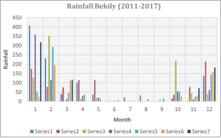
Figure 3. Interannual rainfall in Bekily between 2011 and 2017.
3.1.1. Interannual Rainfall Variability in Bekily
Annual rainfall in Bekily shows high variability between 2000 and 2017, with values ranging from a minimum of 564.3 mm in 2016 to a maximum of 1202.1 mm in 2001. This fluctuation clearly illustrates the climatic irregularities characteristic of the semi-arid climate of the region.
Table 3. Interannual rainfall in Bekily between 2000 and 2017.

Year

Rainfall (mm)

2000

801,1

2001

1202,1

2002

586,5

2003

956,3

2004

635,4

2005

1104,69

2011

1025,41

2012

882,1

2013

819,7

2014

663,4

2015

687,9

2016

564,3

2017

689,1

Source: Bekily Anti-Locust Service, 2025
According to the interannual rainfall table, the wet years are mainly concentrated around 2001 (1,202.1 mm) and 2005 (1,104.7 mm), which represent the wettest years of the 2000–2017 period. These years are characterized by abundant rainfall during the wet season, promoting significant recharge of the Menarandra River’s flows and temporarily mitigating the effects of drought. The year 2011 (1,025.4 mm) can also be considered relatively wet, with sufficient rainfall to support the river’s hydrological functioning. In semi-arid tropical regions, such wet years play a key role in hydrological recharge, although their effects often remain limited in time in the absence of regular rainfall .
Conversely, several dry to moderately dry years are observed, notably 2000 (801.1 mm), 2003 (956.3 mm), 2012 (882.1 mm), 2013 (819.7 mm), and 2017 (689.1 mm). These years are characterized by limited rainfall and unfavorable temporal distribution, with long rainless periods. This situation leads to a partial reduction in river flows and increases the vulnerability of rain-fed agricultural systems. Studies show that in semi-arid areas, even moderate rainfall deficits can have significant hydrological and socio-economic impacts .
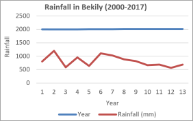
Figure 4. Interannual rainfall in Bekily between 2000 and 2017.
Finally, the peak drought years, such as 2002 (586.5 mm), 2004 (635.4 mm), 2014 (663.4 mm), and 2016 (564.3 mm), correspond to the most deficient periods of the studied series. These years are characterized by very low annual totals, often concentrated in only a few months, followed by long rainless periods. The recurrence of such conditions in intermittent rivers leads to prolonged drying of the riverbed, increased fragmentation of the hydrographic network, and a loss of ecological continuity . These processes are clearly observed in the Menarandra River, where prolonged drought accentuates the fragmentation of the riverbed and sustainably complicates local agricultural and pastoral activities.
3.1.2. Interannual Rainfall Variability and Menarandra River Flow Response
Table 4. Annual rainfall in Bekily (2011–2017), standardized anomalies, and observed riverbed drying of the Menarandra River.

Year

Annual Rainfall (mm)

Mean 2011–2017 (mm)

Deviation from Mean (mm)

Standardized Anomaly

Drying Comments

2011

1025,4

768

+257.4

+1.43

Wet year, continuous flow

2012

882,1

768

+114.1

+0.71

Slightly wet year, reduced but continuous flow

2013

819,7

768

+51.7

+0.32

Year close to average, intermittent flow

2014

663,4

768

-104.6

-0.58

Deficit year, partial drying of riverbed

2015

687,9

768

-80.1

-0.44

Deficit year, riverbed fragmentation

2016

564,3

768

-203.7

-1.23

Very deficit year, prolonged drying

2017

689,1

768

-78.9

-0.48

Deficit year, limited flow

Source: Service Anti-Locust (VALALA), Bekily Meteorological Station (2011–2017), calculations by the authors
The Table 4 shows that annual rainfall in Bekily exhibits strong interannual variability, with totals ranging from 564.3 mm in 2016 to 1,025.4 mm in 2011. Standardized anomalies highlight deficit years (2012, 2016, 2017) and surplus years (2011, 2015), clearly illustrating the climatic variability in southern Madagascar. This variability is directly correlated with the observed drying of the Menarandra Riverbed: years with low effective rainfall coincide with fragmentation and prolonged drying of the river course, confirming the crucial role of precipitation in sustaining the intermittent hydrological regime of the river.
3.1.3. Annual Effective Rainfall (Pe) and Its Relationship with the Menarandra River Flow (2011–2017)
The variability of annual rainfall is a critical factor controlling the flow regime of the Menarandra River. Not all precipitation contributes directly to river discharge, as part of it is lost through infiltration, evaporation, and soil storage. To quantify the portion of rainfall that effectively generates runoff, the annual effective rainfall (Pe) was calculated using the Turkish formula:
Pe=P2P+P2+L2=1025,421025,4+1025,42+1002=10511602055,0=511, 7 mm (2011)
1) Pe = effective rainfall (mm)
2) P = annual precipitation (mm)
3) T = mean annual temperature (°C)
4) L = temperature-related factor representing atmospheric demand
Using this Turkish formula, we will examine the effect of rainfall fluctuations on the river discharge and on the continuity of its flow in the table below.
Table 5. Annual Effective Rainfall (Pe) and Menarandra River Flow Characteristics (2011–2017).

Year

Annual Rainfall P (mm)

Effective Rainfall Pe (mm)

Flow Comments

2011

1025.4

512

Wet year, continuous flow

2012

882.1

433

Slightly wet year, reduced but continuous flo

2013

819.7

404

Near-average year, intermittent flow

2014

663.4

328

Deficit year, partial riverbed drying

2015

687.9

341

Deficit year, riverbed fragmentation

2016

564.3

285

Very deficit year, prolonged riverbed drying

2017

689.1

342

Deficit year, limited flow

Source: Service Anti-Locust (VALALA), Bekily Meteorological Station (2011–2017), calculations by the authors
Table 5 highlights the close relationship between annual rainfall variability, effective rainfall (Pe), and the flow regime of the Menarandra River during the period 2011–2017. Years characterized by high annual rainfall and high effective rainfall values, such as 2011 and 2012, exhibit continuous river flow, reflecting favorable hydrological conditions and sustained hydraulic continuity. As annual rainfall decreases, a significant reduction in effective rainfall is observed. During near-average years, such as 2013, the decline in Pe leads to intermittent flow, reflecting reduced runoff generation and increased water losses through infiltration and evaporation. This situation corresponds to a transitional hydrological state between continuous flow and riverbed drying. Deficit and very deficit years (2014–2017), particularly 2016, are characterized by low Pe values associated with partial to prolonged drying of the riverbed. These conditions indicate a breakdown of hydraulic continuity, as effective rainfall becomes insufficient to maintain permanent flow. The results show that even moderate decreases in annual rainfall can strongly affect effective rainfall and, consequently, river discharge, as illustrated in Figure 5 below. Overall, this analysis confirms that rainfall variability directly controls effective rainfall and governs the flow dynamics of the Menarandra River. The Turkish formula therefore proves to be a relevant tool for quantifying the proportion of precipitation that effectively contributes to runoff and for explaining the prolonged riverbed drying observed in the Bekily District under semi-arid climatic conditions.
3.2. Influence of Rainfall Variability on the Drying of the Menarandra Riverbed
The analysis of the monthly mean flows of the Menarandra River at Bekily, covering the period 1965–1968 , allows for understanding the direct effect of rainfall variability on the river’s hydrology and, consequently, on its drying.
3.2.1. Flow and Discharge of the Menarandra River at Bekily
The hydrological data highlight very marked seasonal variations in the flow of the Menarandra River, closely linked to the annual distribution of rainfall. During the wet season, which extends from December to March, flows reach their maximum values, reflecting a rapid response of the watershed to rainfall concentrated over a short period. The highest flows are observed in February, with a peak reaching 69.3 m³/s in 1965–1966 and 42.7 m³/s in 1967–1968, emphasizing the major role of this month in the river’s hydrological supply. January and December also show significant flows, although marked by high interannual variability, as evidenced by the range observed in January, where values fluctuate between 17.5 and 39.8 m³/s depending on the year. Conversely, at the end of the wet season, flows drop sharply, marking the onset of a prolonged dry season from April to November. Between May and August, flows become extremely low, often below 1 m³/s, reflecting a clear decrease in the river’s water supply. June, July, and August are characterized by almost zero flows, with values ranging between 0.226 and 0.42 m³/s, indicating a near disappearance of flow in the minor channel.
Table 6. Monthly Mean Flows of the Menarandra River at Bekily (1965–1968) in m³/s.

Year/month

65-66

66-67

67-68

N

06.19

02.03

07.41

D

28.8

16.9

19.9

J

17.5

39.8

18.5

F

69.3

40.2

20.9

M

3.43

42.7

05.26

A

2.36

7.24

01.97

M

.973

01.26

.25

J

.879

00.67

.50

J

.339

.42

.20

A

.226

.19

.10

S

4.84

.57

.02

O

.220

04.02

3.38

Annual

11.3

12.9

6.53

Source: Chaperon et al. 1993
The most recent hydrological measurements available for the Menarandra River indicate an annual mean flow of approximately 12.9 m³/s at the Bekily station . This is consistent with historical flows recorded between 1965 and 1968 (ranging from 11.3 to 12.9 m³/s for the available measurement periods). In brief, these mean flow data highlight that the prolonged drying of the Menarandra is directly linked to rainfall variability. This relationship underscores the hydrological vulnerability of the region and the dependence of local populations on the wet seasons for water supply and agriculture. In hydrology , the following empirical ratios are often applied:
1) Dry years: 0,5 to 0,6 of the interannual mean flow
2) Wet years: 1,5 to 1,6 of the interannual mean flow
By applying these coefficients to 220 mm:
1) H Decennial dry year=220×0,55≈120 mm
2) H Decennial wet year=220×1,55≈340 mm
3) C Runoff coefficient (C)= (220 mm / 820 mm) × 100≈ 27%
Table 7. Water depth discharged in the Menarandra.

Station

Menarandra

Interannual discharged water depth H (mm)

220

H Decennial dry year (mm)

120

H Decennial wet year (mm)

340

Runoff coefficient (%)

27

Source: Chaperon et al. 1993.
The calculated values show that the Menarandra has a relatively low runoff coefficient (27%), characteristic of semi-arid regimes, with strong variability between dry and wet years. The application of empirical coefficients highlights that the discharged water depth can nearly triple between a dry year (120 mm) and a wet year (340 mm), confirming the river’s sensitivity to interannual rainfall variability.
3.2.2. Spatio-temporal Evolution of Riverbed Drying
The study of the spatio-temporal evolution of the Menarandra Riverbed drying is based on the combined analysis of rainfall data and satellite images from Google Earth for the years 2014 and 2018. This approach allows for the identification of both the regression of water-covered areas and the progressive fragmentation of the riverbed along the Bekily section.
The maps generated from Google Earth satellite images of December 2014 and October 2018 clearly highlight the spatio-temporal dynamics of the Menarandra Riverbed drying at Bekily. In December 2014, the presence of water, shown in blue, remains relatively extensive, particularly along the meanders and certain sections of the minor and middle channels. These areas indicate that flow was still continuous or nearly continuous, despite the challenging climatic conditions, suggesting residual hydrological recharge from the previous wet season.
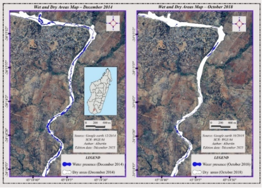
Figure 5. Spatial evolution of water presence and dried areas in the Menarandra Riverbed at Bekily between December 2014 (wet season) and October 2018 (end of the dry season), based on Google Earth images processed in QGIS.
In contrast, the October 2018 image reveals a clear and widespread reduction of water-covered areas. The riverbed appears largely dry and highly fragmented, with long white stretches corresponding to sections completely devoid of flow. The comparison between the two dates highlights a marked regression of water areas and advanced fragmentation of the hydrographic network, characterized by the isolation of discontinuous water pockets. This configuration reflects the progressive shift of the Menarandra toward an intermittent hydrological regime, highly dependent on seasonal rainfall inputs.
This drying dynamic occurs within a semi-arid climatic context, marked by prolonged rainfall deficits between 2014 and 2018, promoting a spatially extensive drying of the riverbed. The consequences of this evolution are multiple: reduction in local water uses, disruption of aquatic biodiversity, and alteration of the riverbed morphology, with an increased risk of erosion and bank degradation during seasonal floods. Observations from satellite imagery are fully consistent with testimonies collected from local communities during field surveys. These reports indicate a progressive reduction in the duration and continuity of flows, making access to water increasingly difficult for agriculture and livestock, particularly between April and September, corresponding to the prolonged dry season.
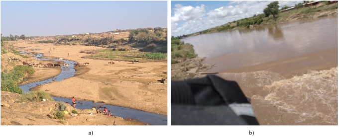
Figure 6. (a and b): Field photographs illustrating the state of the Menarandra Riverbed at Bekily in October (a) and December (b) 2025 along the central Bekily section. Author, 2025.
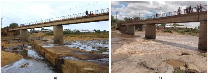
Figure 7. (a and b): Field photographs illustrating the state of the Menarandra Riverbed at Bekily in October (a) and December (b) 2025 at the section below the bridge. Author, 2025.
3.3. Impacts of Prolonged Drying on Riverbed Morphology
The prolonged drying of rivers, as observed in the Menarandra River, leads to significant morphological transformations, affecting natural erosion and sedimentation processes as well as the continuity of the riverbed. These changes have major repercussions on the ecological dynamics and geomorphological stability of the watershed.
3.3.1. Modification of Sedimentation and Erosion Processes
In semi-arid areas, sediment transport is strongly influenced by the variability of rainfall and flows, as the majority of solid transport occurs during irregular floods linked to rainfall, making the sediment balance highly variable and directly dependent on hydrological variability . The prolonged drying of the Menarandra Riverbed profoundly affects natural sedimentation and erosion processes. In semi-arid watersheds such as southern Madagascar, hydrological regimes are highly irregular, with periods of low flow followed by sudden floods during intense rainfall. A key study on the hydrology of Malagasy rivers highlights that rivers in southern Madagascar exhibit very irregular hydrological regimes, characterized by long low-flow periods interrupted by flood events during the rainy season . In intermittent and ephemeral rivers, the discontinuity of flows interrupts hydrological connectivity longitudinally, laterally, and vertically, which directly influences energy transfers, material transport, and the spatial organization of fluvial processes . Under these conditions, flood events are the main periods during which sediments are mobilized and transported, while the long periods of low flow favor the deposition of fine materials and the stabilization of sediment bars in the minor channel, gradually modifying the river morphology.
In the field, this dynamic is observed in dried sections of the Menarandra, where previously continuous flow surfaces now show areas of increased sedimentation and intermittent erosion, corroborating the influence of flow variability on the morphological evolution of the riverbed.
Table 8. Riverbed width (in m).

Width (m)

Max

Min

Average

Natural channel

189

43

80

2014

40

1

15,47

2018

31

0,3

9,57

Source: Google Earth, 2025
The data from Figure 5, reported in this Table 6, show that the width of the Menarandra Riverbed significantly decreased between 2014 and 2018. The average width dropped from 15.47 m in 2014 to 9.57 m in 2018, reflecting increased fragmentation and a loss of continuity of the river, a direct consequence of prolonged drought periods and rainfall variability in the Bekily district.
Table 9. Measurements of Depth, Minor and Middle Channel width in October 2025.

RIVERBED LOCATION

Middle channel

Minor channel

Measurement points

Depth (cm)

Width (m)

Depth (cm)

Width (m)

Point 1. North of Bekily town center

45

01,3

27

01,0

Point 2. Under the bridge in Bekily town center

55

02,0

40

01,8

Point 3. South of Bekily town center

63

03,0

55

02,1

Source: Field survey, 2025
Table 9 presents the measurements of depth and width of the middle and minor channels of the Menarandra River, recorded in October 2025 at three observation points located to the north, center, and south of Bekily town. The results show a progressive increase in both depth and width of the channel, for both the middle and minor beds, from upstream to downstream. This trend reflects a greater flow capacity of the river towards the south, while the lower values observed in the north indicate a narrower and shallower channel, more likely to be affected by drying during periods of low rainfall. The observed variations in riverbed dimensions reflect a contrasting hydromorphological dynamic along the Menarandra River.
3.3.2. Increased Fragmentation of the Riverbed
The prolonged drying of the Menarandra Riverbed leads to increased fragmentation of the river, characterized by the formation of discontinuous sections and isolated pockets of stagnant water. This phenomenon is typical of intermittent rivers in semi-arid areas, where the reduction of perennial flow decreases the continuity of the hydrographic network and alters the spatial distribution of water . Fragmentation of riverbeds changes ecological and hydrological connectivity, resulting in temporary isolation of aquatic habitats and redistribution of sediments, which affects both the morphology and functionality of the river .
In the case of the Menarandra, field observations in 2025 show continuous dried sections over several kilometers, interrupted only by residual water pockets, confirming the effect of rainfall variability on the discontinuity of the riverbed. This fragmentation has direct implications for local activities: access to water for agriculture and livestock is reduced, and fishing in the minor channel becomes sporadic, increasing the socio-economic vulnerability of riparian communities .
Table 10. Riverbed area (in ha).

Year

Area (ha)

Observations

Natural channel

62,271

Stable area

2018

3,185

Strong reduction, but some connected areas remain

2014

10,68

Extreme fragmentation, with small isolated water pockets

Source: Google Earth, 2025
The values presented in the table, calculated from satellite images of 2014 and 2018, show a dramatic reduction in the water-covered area of the Menarandra, decreasing from 10.68 ha in 2014 to only 3.19 ha in 2018. This decline reflects progressive fragmentation and a loss of continuity of the riverbed, a direct consequence of prolonged drought periods and rainfall variability in the Bekily district .
The comparative study of satellite images from December 2014 and October 2018 reveals a marked evolution in the continuity of the Menarandra Riverbed. In 2014, the riverbed still exhibited connected sections, with a few localized dry areas, but the main flows remained visible throughout the studied section. Polygons traced in QGIS show that the water surface is mainly concentrated in the minor channel and the deepest areas of the middle channel, confirming partial intermittence (Figure 5).
On the other hand, the 2018 images highlight increased fragmentation, with long sections of the riverbed completely dry and isolated water pockets, reflecting a highly intermittent river regime. The comparison between the two dates shows a progressive reduction of water-covered areas by approximately 35–40 % along this section, illustrating the impact of rainfall variability during 2015–2017 on flow maintenance (Figure 5). These observations confirm that prolonged drought periods exacerbate the discontinuity of the riverbed, which has direct consequences on morphology, sedimentation, and water availability for riparian communities. In intermittent rivers, including the Menarandra, the reduction of perennial flow leads to a loss of longitudinal and lateral connectivity, affecting both the bed morphology and the ecological functionality of aquatic habitats.
3.4. Negative Impacts of the Concrete Dam at FANAGOLA on Riverbed Continuity
Since the beginning of 2025, a Chinese company has constructed a concrete dam approximately 11 meters high and more than 9 meters long on the Menarandra Riverbed, at the Fanagola section in the Ambahita commune, north of the Bekily district. This structure was built to retain river water, which is needed in large quantities for the company’s operational activities. Field observations have already revealed the negative impacts of this infrastructure on the continuity of the riverbed. Indeed, water is strongly retained upstream of the dam, while no flow continuity is observed downstream of the Menarandra River, despite it being located only four meters below the structure.
This disruption of hydrological continuity results in a significant reduction of downstream flows, exacerbating the prolonged drying of the riverbed, already weakened by rainfall variability. Environmentally, this situation leads to the degradation of aquatic and riparian ecosystems, disrupting natural habitats, local biodiversity, and water use by downstream communities. In response, the local community has already reported the issue to the competent authorities, from the local level up to state institutions. However, no compromise or sustainable solution has been found to date, maintaining the observed hydrological and environmental impacts on the Menarandra River.
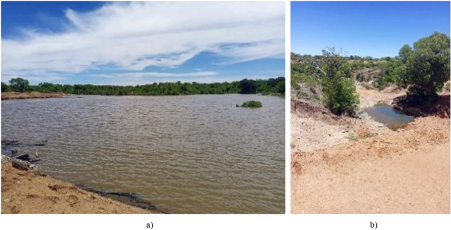
Figure 8. (a and b): Field photographs illustrating the state of the Menarandra Riverbed at the Fangola section. Jeunes de Bekily, 2025.
4. Conclusion
The study of rainfall variability and the prolonged drying of the Menarandra Riverbed in Bekily (2000–2017) demonstrates that the semi-arid climate of southern Madagascar causes strong intermittency in river flows. Detailed analysis of precipitation data, historical discharge records, and effective rainfall (Pe) calculations confirms that dry or deficit years lead to riverbed fragmentation and significant reductions in water-covered areas, while wet years temporarily maintain flow continuity. Satellite imagery (2014–2018) and field measurements (2025) reveal morphological changes, sediment accumulation, erosion, and increased fragmentation, further exacerbated by the Fanagola dam, which disrupts downstream flow continuity. These transformations directly impact water availability, aquatic biodiversity, and agricultural and pastoral activities. Therefore, this study highlights the interdependence between climate variability, hydrological regimes, and anthropogenic pressures, providing a solid scientific basis for guiding sustainable water and natural resource management in the semi-arid regions of southern Madagascar.
Abbreviations

AIM

Association Inter-cooperation of Madagascar

ADRA

Adventist Development and Relief Agency

PRD

Regional Development Plan

UNICEF

United Nations International Children’s Emergency Fund

QGIS

Quantum Geographic Information System

Author Contributions
Tinahindraza Mampionona Albertin is the sole author. The author read and approved the final manuscript.
Conflicts of Interest
The authors declare that we have no conflict of interest.
References
[1] Région Androy. (2013). Monograph of the Androy Region. Ministry of Interior and Decentralization, Republic of Madagascar, Antananarivo.
[2] Acuña, V., Datry, T., Marshall, J., Barceló, D., & Sabater, S. (2014). Why should we care about temporary waterways? Science of the Total Environment, 486, 1–7.
[3] Clicours. (n.d.). Hydrography of Madagascar: Rivers and hydrological regimes. Online geographic resource.
[4] Battistini, R. (1965). Morphological and hydrological issues of southern Madagascar. Annals of Géography, 74(402), 1–28.
[5] Chaperon, P., Danloux, J., & Ferry, L. (1993). Rivers and streams of Madagascar. ORSTOM, Paris, 874 p.
[6] PRD Androy Region. (2024). Regional Development Plan (PRD) of the Androy Region. Androy Regional Council, Madagascar.
[7] Donque, G. (1975). Climate and hydrology of southern Madagascar. University of Madagascar, Department of Geography, Antananarivo.
[8] Randriamahefasoa, H., Rajerison, M., & Rasolofo, J. (2012). Cyclones and hydrological impacts in southern Madagascar. Malagasy Journal of Geography, 6(2), 45–58.
[9] Nicholson, S. E. (2000). The nature of rainfall variability over Africa on time scales of decades to millennia. Global and Planetary Change, 26(1–3), 137–158.
[10] IPCC. (2014). Climate Change 2014: Impacts, Adaptation, and Vulnerability. Contribution of Working Group II to the Fifth Assessment Report of the Intergovernmental Panel on Climate Change. Cambridge University Press, Cambridge, UK.
[11] Datry, T., Larned, S. T., & Tockner, K. (2014). Intermittent rivers: A challenge for freshwater ecology. BioScience, 64(3), 229–235.
[12] Republic of Madagascar – Prime Minister’s Office / CPGU – GEO & ECO Consult. (2014). Development of flood prevention standards for road infrastructure in Madagascar. Hydrological characteristics of southern rivers, p. 51.
[13] Rodríguez-Blanco, J. D., Walling, D. E., & He, Q. (2010). Rainfall–runoff–sediment transport relationships in semi-arid Mediterranean catchments. Journal of Hydrology, 386(1–4), 221–234.
[14] Boulton, A. J., Rolls, R. J., Jaeger, K. L., & Datry, T. (2017). Hydrological connectivity in intermittent rivers and ephemeral streams. In T. Datry, N. Bonada, & A. Boulton (Eds.), Intermittent Rivers and Ephemeral Streams: Ecology and Management (pp. 79–108). Academic Press / Elsevier.
[15] Larned, S. T., Datry, T., Arscott, D. B., & Tockner, K. (2010). Emerging concepts in temporary river ecology. Freshwater Biology, 55(4), 717–738.
[16] Google Earth. (2023). Menarandra River Basin, Southern Madagascar. Satellite imagery. Google Earth Pro.
Cite This Article
  • APA Style

    Albertin, T. M. (2026). Rainfall Variability and Prolonged Drying of the Menarandra Riverbed (2000–2017) in the District of Bekily (Southern Madagascar). Earth Sciences, 15(1), 30-43. https://doi.org/10.11648/j.earth.20261501.13

    Copy | Download

    ACS Style

    Albertin, T. M. Rainfall Variability and Prolonged Drying of the Menarandra Riverbed (2000–2017) in the District of Bekily (Southern Madagascar). Earth Sci. 2026, 15(1), 30-43. doi: 10.11648/j.earth.20261501.13

    Copy | Download

    AMA Style

    Albertin TM. Rainfall Variability and Prolonged Drying of the Menarandra Riverbed (2000–2017) in the District of Bekily (Southern Madagascar). Earth Sci. 2026;15(1):30-43. doi: 10.11648/j.earth.20261501.13

    Copy | Download

  • @article{10.11648/j.earth.20261501.13,
      author = {Tinahindraza Mampionona Albertin},
      title = {Rainfall Variability and Prolonged Drying of the Menarandra Riverbed (2000–2017) in the District of Bekily (Southern Madagascar)},
      journal = {Earth Sciences},
      volume = {15},
      number = {1},
      pages = {30-43},
      doi = {10.11648/j.earth.20261501.13},
      url = {https://doi.org/10.11648/j.earth.20261501.13},
      eprint = {https://article.sciencepublishinggroup.com/pdf/10.11648.j.earth.20261501.13},
      abstract = {The Menarandra River, located in the Androy region of southern Madagascar, flows through a semi-arid environment characterized by severe water stress, a long dry season lasting seven to nine months, and a short, highly variable rainy season concentrated between December and March. Rainfall records from the Bekily meteorological station over 2000–2017 highlight pronounced interannual variability, with alternating wet years (e.g., 2001, 2005, 2011, annual totals >1,000 mm) and deficit years with totals below 700 mm (e.g., 2002, 2004, 2016, 2017). To better link raw rainfall data to effective rainfall in terms of hydrological response, the analysis incorporates the Turc formula, widely used in water balance studies to estimate potential evapotranspiration and effective rainfall. This approach allows a more precise characterization of hydrological conditions associated with rainfall variability and their potential role in riverbed drying. Rainfall analysis is complemented by qualitative interpretation of Google Earth satellite images processed in QGIS, together with field observations. Comparison of images from December 2014 and October 2018 reveals marked reduction and fragmentation of water-covered areas, indicating increasing spatial discontinuity of surface flow. While the temporal correspondence between rainfall variability and riverbed drying suggests a strong association, river intermittency likely reflects the combined influence of seasonal and interannual rainfall patterns and local hydrological controls. Overall, results indicate a progressive shift of the Menarandra toward a more intermittent flow regime, improving understanding of river drying dynamics in semi-arid southern Madagascar and informing sustainable water resource management under increasing drought conditions.},
     year = {2026}
    }
    

    Copy | Download

  • TY  - JOUR
    T1  - Rainfall Variability and Prolonged Drying of the Menarandra Riverbed (2000–2017) in the District of Bekily (Southern Madagascar)
    AU  - Tinahindraza Mampionona Albertin
    Y1  - 2026/02/02
    PY  - 2026
    N1  - https://doi.org/10.11648/j.earth.20261501.13
    DO  - 10.11648/j.earth.20261501.13
    T2  - Earth Sciences
    JF  - Earth Sciences
    JO  - Earth Sciences
    SP  - 30
    EP  - 43
    PB  - Science Publishing Group
    SN  - 2328-5982
    UR  - https://doi.org/10.11648/j.earth.20261501.13
    AB  - The Menarandra River, located in the Androy region of southern Madagascar, flows through a semi-arid environment characterized by severe water stress, a long dry season lasting seven to nine months, and a short, highly variable rainy season concentrated between December and March. Rainfall records from the Bekily meteorological station over 2000–2017 highlight pronounced interannual variability, with alternating wet years (e.g., 2001, 2005, 2011, annual totals >1,000 mm) and deficit years with totals below 700 mm (e.g., 2002, 2004, 2016, 2017). To better link raw rainfall data to effective rainfall in terms of hydrological response, the analysis incorporates the Turc formula, widely used in water balance studies to estimate potential evapotranspiration and effective rainfall. This approach allows a more precise characterization of hydrological conditions associated with rainfall variability and their potential role in riverbed drying. Rainfall analysis is complemented by qualitative interpretation of Google Earth satellite images processed in QGIS, together with field observations. Comparison of images from December 2014 and October 2018 reveals marked reduction and fragmentation of water-covered areas, indicating increasing spatial discontinuity of surface flow. While the temporal correspondence between rainfall variability and riverbed drying suggests a strong association, river intermittency likely reflects the combined influence of seasonal and interannual rainfall patterns and local hydrological controls. Overall, results indicate a progressive shift of the Menarandra toward a more intermittent flow regime, improving understanding of river drying dynamics in semi-arid southern Madagascar and informing sustainable water resource management under increasing drought conditions.
    VL  - 15
    IS  - 1
    ER  - 

    Copy | Download

Author Information
  • Abstract
  • Keywords
  • Document Sections

    1. 1. Introduction
    2. 2. Methodology
    3. 3. Results and Discussion
    4. 4. Conclusion
    Show Full Outline
  • Abbreviations
  • Author Contributions
  • Conflicts of Interest
  • References
  • Cite This Article
  • Author Information